Crossing Districts
North West Delhi, North Delhi
Purpose and Objectives
Purpose and Objectives of NSP to Kashmiri Gate
Article Introduction:
The proposed road from Netaji Subhash Place (NSP) to Kashmiri Gate stands as a testament to urban planning aimed at enhancing connectivity, reducing travel time, and alleviating traffic congestion in the bustling city of Delhi. This ambitious project holds multifaceted objectives designed to address the growing demands of the city's infrastructure and improve the overall commuting experience for its residents.
Details:
| Road Name | NSP to Kashmiri Gate |
|---|---|
| Distance | 9.96 km |
| Travel Time | 10 min |
| Actual Time | 32 min |
| Save Time | 22 min |
| Save Time Percentage | 68.75% |
| Realtime Distance & Time | 11.6 km |
| Crossing Districts | North West Delhi, North Delhi |
| Total Interchange | 10 |
| Total Underpass | - |
Route Map:
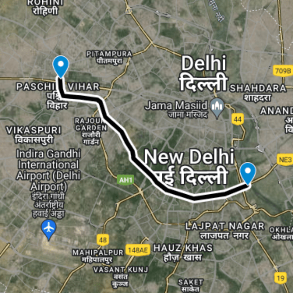
- Starting from Wazirpur Flyover, NSP: Latitude and longitude - 28.69318, 77.15297
- Passing through Keshav Puram, Tri Nagar: Latitude and longitude - 28.69463, 77.15919
- Crossing on K C Goel Marg, Ashok Vihar: Latitude and longitude - 28.69778, 77.16937
- Passing through Satyawati Collage Road: Latitude and longitude - 28.69689, 77.1822
- Passing through Inder Chandra Shastri Marg: Latitude and longitude - 28.67848, 77.19154
- Crossing at Ghanta Ghar Chowk, Malka Ganj: Latitude and longitude - 28.67643, 77.20261
- Passing through Kamala Nagar, T Point Hans Raj College Marg: Latitude and longitude - 28.67828, 77.20802
- Crossing at Civil Line, Ending at ISBT Kashmiri Gate: Latitude and longitude - 28.6771, 77.22467 to 28.66866, 77.22712
Proposed Interchanges:
The road encompasses a total of 10 interchanges strategically positioned to facilitate seamless connectivity:
- Starting from Wazirpur Flyover, NSP: Latitude and longitude - 28.69318, 77.15297
- Interchange at Keshav Puram, Tri Nagar: Latitude and longitude - 28.69463, 77.15919
- Interchange at K C Goel Marg, Ashok Vihar: Latitude and longitude - 28.69778, 77.16937
- Interchange at Satyawati Collage Road: Latitude and longitude - 28.69689, 77.1822
- Interchange at Inder Chandra Shastri Marg: Latitude and longitude - 28.67848, 77.19154
- Interchange at Ghanta Ghar Chowk, Malka Ganj: Latitude and longitude - 28.67643, 77.20261
- Interchange at Kamala Nagar: Latitude and longitude - 28.67828, 77.20802
- Interchange at T Point Hans Raj College Marg: Latitude and longitude - 28.68055, 77.21514
- Interchange at Civil Line: Latitude and longitude - 28.6771, 77.22467
- Interchange at ISBT Kashmiri Gate: Latitude and longitude - 28.66866, 77.22712
Red Lights and Areas Benefited:
- Red Lights:
- Wazirpur Flyover, NSP
- Keshav Puram, Tri Nagar
- K C Goel Marg, Ashok Vihar
- Satyawati Collage Road
- Inder Chandra Shastri Marg
- Ghanta Ghar Chowk, Malka Ganj
- Kamala Nagar
- T Point Hans Raj College Marg
- Civil Line
- ISBT Kashmiri Gate
- Areas Benefited:
- Netaji Subhash Place
- Tri Nagar
- Ashok Vihar
- Malka Ganj
- Kamala Nagar
- Civil Line
- Kashmiri Gate
Benefits and Public Satisfaction:
- Time Savings: Commuters can save a significant amount of time, up to 68.75%, leading to more efficient and productive daily routines.
- Reduced Traffic Stress: The strategic placement of interchanges and the smooth flow of traffic aim to reduce stress levels associated with congestion.
- Enhanced Connectivity: Improved connectivity between major areas like NSP, Tri Nagar, and Kashmiri Gate contributes to a well-connected cityscape.
- Economic Impact: Efficient road networks often lead to increased economic activities and growth in the surrounding areas.
- Public Satisfaction: The reduced travel time, minimized traffic congestion, and enhanced connectivity contribute to higher public satisfaction.
In conclusion, the NSP to Kashmiri Gate road project addresses key transportation challenges in North Delhi, focusing on saving time, reducing congestion, and enhancing overall connectivity. The strategically planned interchanges and efficient routing demonstrate a commitment to urban development that aligns with the city's evolving needs.
Route Map
NSP to Kashmiri Gate
1
Start from Wazirpur Flyover, Netaji Subhash Place
(Latitude and longitude: 28.69318, 77.15297): Begin your journey at Wazirpur Flyover, Netaji Subhash Place.
2
Passing through Keshav Puram, Tri Nagar
(Latitude and longitude: 28.69463, 77.15919): Travel through the areas of Keshav Puram and Tri Nagar.
3
Passing through Wazirpur
(Latitude and longitude: 28.69641, 77.16431): Continue your route, passing through Wazirpur
4
Crossing on K C Goel Marg, Ashok Vihar
(Latitude and longitude: 28.69778, 77.16937): Cross K C Goel Marg in the Ashok Vihar area.
5
Crossing on Satyawati College Road
(Latitude and longitude: 28.69689, 77.1822): Proceed by crossing Satyawati College Road.
6
Passing through Ashok Vihar
(Latitude and longitude: 28.6924, 77.18415): Travel through the Ashok Vihar locality
7
Passing through Rana Pratab Nagar
(Latitude and longitude: 28.68426, 77.18858): Continue your journey through Rana Pratab Nagar.
8
Passing Between Sultan Puri - Mangolpuri
(Latitude and longitude: 28.69374, 77.08033): Traverse through the corridor between Sultan Puri and Mangolpuri, ensuring seamless travel options.
9
Crossing On Metro Line, Nangloi
(Latitude and longitude: 28.68166, 77.07638): Navigate across the Metro Line in Nangloi, ensuring smooth travel along the expressway.
10
Passing From Peera Garhi
(Latitude and longitude: 28.67427, 77.07749): Drive through Peera Garhi, contributing to the overall connectivity of this region.
11
Passing From Paschim Vihar
(Latitude and longitude: 28.66742, 77.07823): Travel through Paschim Vihar, enhancing connectivity in this locality.
12
Ending From Nala Road, Saiyed Village
(Latitude and longitude: 28.65536, 77.08186): The journey concludes at Nala Road in Saiyed Village, marking the endpoint of the North West Linking Road journey.
Proposed Interchanges
Total Interchange Point : 10
1.Start from Interchange On Wazirpur Flyover, Netaji Subhash Place , Latitude and longitude : 28.69318, 77.15297
2.Interchange On Keshav Puram, Tri Nagar, Latitude and longitude :28.69463, 77.15919
3.Interchange On K C Goel Marg,Ashok Vihar, Latitude and longitude :28.69778, 77.16937
4. Interchange On Satyawati Collage Road,Latitude and longitude :28.69689, 77.1822
5. Interchange On Inder Chandra Shastri Marg,Latitude and longitude :28.67848, 77.19154
6. Interchange On Ghanta Ghar Chowk,Latitude and longitude :28.67643, 77.20261
7. Interchange On Malka Ganj,,Latitude and longitude :28.67828, 77.20802
8. Interchange On T Point Hans Raj College Marg,Latitude and longitude :28.68055, 77.21514
9. Interchange On Civil Line,Latitude and longitude :28.6771, 77.22467
10. Interchange On ISBT Kashmiri Gate,Latitude and longitude :28.66866, 77.22712
Purposed Roads of India
Purposed Roads of North East India


