Narayna to Peera Garhi

Central Delhi, West Delhi, North West Delhi

Purpose and Objectives of Narayna to Peera Garhi Road

Article Introduction:

The proposed Narayna to Peera Garhi road project is a significant initiative designed to address critical challenges in urban mobility and connectivity in Central Delhi, West Delhi, and North West Delhi. With a clear set of purposes and objectives, the project aims to create a more efficient transportation network, minimize travel time, and enhance the overall quality of life for residents and commuters in the region.

Objectives:

  1. Enhanced Connectivity: The primary objective is to enhance connectivity between Narayna and Peera Garhi, creating a more accessible and interconnected urban landscape. Improved road connectivity is crucial for supporting economic activities, reducing isolation, and fostering regional development.
  2. Traffic Flow Optimization: The project aims to optimize traffic flow along the route, strategically planning road layouts and intersections to reduce congestion and enhance the overall efficiency of the transportation network.
  3. Reduction of Red Lights: A key goal is the reduction of red lights along the road, contributing to a smoother and more uninterrupted traffic flow. This targeted effort is expected to significantly reduce delays and enhance overall road efficiency.
  4. Minimized Travel Time: An essential objective is to minimize travel time for commuters traveling between Narayna and Peera Garhi. By creating a more direct and efficient route, the project aims to save valuable time for daily commuters.

List of Surrounding Areas Benefited:

  1. Narayna: Residents and businesses in Narayna are expected to benefit from improved connectivity and reduced travel time, leading to enhanced local development.
  2. Mayapuri: The road project is likely to optimize traffic flow and reduce congestion in the Mayapuri area, benefiting both residents and businesses.
  3. Subhash Nagar: Enhanced accessibility and minimized travel time for residents and businesses in Subhash Nagar.
  4. Paschim Vihar: Improved traffic flow and connectivity for the residents and businesses in the Paschim Vihar vicinity.

Time Savings and Traffic Stress Management:

  1. Time Savings: Commuters using the Narayna to Peera Garhi road are expected to save a significant amount of time, contributing to a more efficient daily routine and increased productivity. The exact time savings will depend on the current traffic conditions and the road's design efficiency.
  2. Traffic Stress Management: The project's focus on reducing congestion and optimizing traffic flow aims to effectively manage traffic stress. A smoother commuting experience is anticipated to contribute to reduced stress levels for daily commuters.

Public Satisfaction and Economic Impact:

  1. Public Satisfaction: The enhanced connectivity, reduced travel time, and improved traffic flow are intended to contribute to higher public satisfaction levels. Residents and commuters are likely to appreciate the positive changes brought about by the road project.
  2. Economic Impact: The efficient road network is expected to have a positive economic impact by facilitating smoother transportation of goods and services, fostering economic activities in the surrounding areas.

In conclusion, the Narayna to Peera Garhi road project is a pivotal step towards creating a more connected, efficient, and sustainable urban environment. The project's objectives align with broader goals of urban development, ultimately contributing to the well-being and satisfaction of the local community.

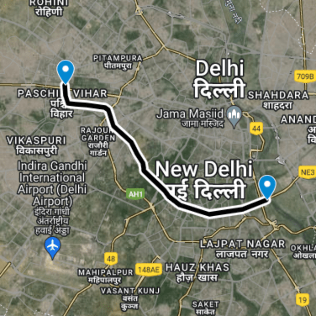
Narayna to Peera Garhi

  • 1

    Start from Mahatma Gandhi Road - Naraina Village

    (Latitude and longitude: 28.6215, 77.13608): Commence your journey at Mahatma Gandhi Road in Naraina Village.

  • 2

    Passing From T Point Satguru Ram Singh Road - Mayapuri

    (Latitude and longitude: 28.62986, 77.12356): Travel through the T Point Satguru Ram Singh Road in Mayapuri

  • 3

    Passing From Hari Nagar

    (Latitude and longitude: 28.63181, 77.11136): Proceed by passing through Hari Nagar.

  • 4

    Crossing On Shivaji Marg - Subhash Nagar

    (Latitude and longitude: 28.64163, 77.10767): Cross Shivaji Marg at Subhash Nagar

  • 5

    Crossing on Sahibi River - Paschim Vihar

    (Latitude and longitude: 28.66173, 77.10467): Cross the Sahibi River and continue towards Paschim Vihar.

  • 6

    Passing From Paschim Vihar

    (Latitude and longitude: 28.67945, 77.09709): Travel through Paschim Vihar.

  • 7

    Ending at Mangolpuri Industrial Area

    (Latitude and longitude: 28.68824, 77.09637): Conclude your route at Mangolpuri Industrial Area

Total Interchange Point  : -7

1 . Interchange On Mahatma Gandhi Road -  Naraina Village ,Latitude and longitude : 28.6215, 77.13608

2. Interchange On T Point  Satguru Ram Singh Road - Mayapuri, Latitude and longitude : 28.62986, 77.12356

3. Interchange On Hari Nagar,  Latitude and longitude : 28.63181, 77.11136

4.Interchange On Crossing Shivaji Marg  ,Subhash Nagar , Latitude and longitude : 28.64163, 77.10767

5 .Interchange On Crossing Sahibi River - Paschim Vihar, Latitude and longitude :28.66173, 77.10467

6. Interchange On Paschim Vihar, Latitude and longitude :28.67945, 77.09709

7. Interchange On Mangolpuri Industrial Area , Latitude and longitude :28.68824, 77.09637

Purposed Roads of India

Purposed Roads of North East India

Leave a Comment

Shopping Cart
Home
Account
Cart
Search